
Drone surveillance
An eye in the sky for car parks, major incidents and site layouts, plus aerial video and photography to capture the event.
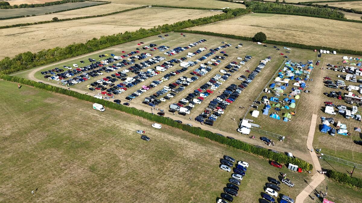
A drone overhead gives our team, and yours, a live view of the whole site that’s impossible to get from the ground — spotting a car park filling up, a bottleneck forming, or an incident developing, in time to act on it.
Beyond live monitoring, we also use drones for site layout surveys before the event, and aerial video and photography during it, giving you footage of your event from angles no ground camera can reach.
From the air we can see every car park, access road and approach route at once. Instead of relying on radio updates from individual gates, event control gets one clear picture of how traffic is building and where it is getting stuck.
That means problems are spotted before they turn into long queues on public roads — so marshalls can be moved, overflow parking opened or traffic rerouted early. It works hand in hand with our Traffic Management and Car Park Management teams on the ground.
When something goes wrong, the first few minutes matter most. A drone gives the control room an immediate overhead picture of what is happening, where it is, and how it is developing — without sending staff into the area blind.
That picture helps guide emergency services, security and stewards to the right place by the quickest route, and shows straight away whether exits, access roads and emergency routes are clear.
Before the event, we fly the site to capture an up-to-date aerial view of the land as it really is — not an old satellite image. It gives everyone involved a shared, accurate picture to plan from.
Those images can sit alongside our CAD site plans, making it easier to agree layouts with clients, contractors and safety advisory groups, and to spot problems like soft ground, slopes or pinch points before anything is built.
We capture high-quality aerial stills and video of your event — the crowds, stages, arenas, car parks and the scale of the whole site. It shows off your event from angles no ground camera can reach.
The footage is useful long after the event ends: for promotion, sponsors, next year’s marketing, and as a record of how the site was set up and how it ran.
Our pilots hold a mix of CAA qualifications, including Operator ID, GVC and A2 CofC. Every flight is planned and flown within CAA rules, so you know the operation is legal and professionally run.
Before we fly, we check the airspace and any restrictions around your site, agree flight areas with the landowner and event organiser, and make sure the flight fits around everything else happening on site.
Throughout the event, the drone gives event control a live overview of the whole site. Decisions are made on what is actually happening, rather than on radio reports alone.
It is especially useful on large or spread-out sites, where no one person on the ground can see everything — and at peak times, when things change quickly.
Every drone operation comes with its own risk assessment and method statement (RAMS), prepared for your site and your event — not a generic template.
We share it with your event safety team so the drone becomes part of your wider safety plan, and everyone knows where and when it will be flying.
From above, we can see how people are moving around the site in a way that is impossible from the ground — where crowds are building, where they are getting stuck, and how quickly areas clear.
That helps your team step in early, before crowding becomes a safety issue, and gives you useful information for improving the layout next year.
Tell us about your event and we’ll put together a plan and a quote.